
AEMET Issues Weather Alerts Across Spain: Rough Seas, Strong Winds and Falling Temperatures
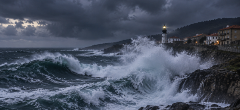
Spain’s State Meteorological Agency (AEMET) has issued weather warnings across eleven autonomous communities for Thursday, November 19, due to rough seas and strong wind gusts. Asturias, Cantabria, Galicia and the Basque Country are under orange-level coastal warnings, with waves expected to reach between six and eight metres in some parts of the Galician coastline.

A weather front moving across the Iberian Peninsula is also bringing rainfall, a widespread drop in temperatures and snowfall in northern mountain areas. The conditions are prompting calls for caution, particularly along exposed coastlines and in areas affected by strong winds.
Four Northern Regions Under Orange Alerts for Rough Seas
The most severe conditions are concentrated along Spain’s Atlantic and Cantabrian coasts. AEMET has issued orange-level coastal warnings in four autonomous communities:

- Galicia: Warnings cover the coastal areas of A Coruña, Lugo and Pontevedra, where waves could reach between six and eight metres.
- Asturias: Both the western and eastern coastal areas are affected, with waves potentially reaching seven metres.
- Cantabria: The coastline is under an orange warning for combined sea conditions, with waves of up to seven metres.
- Basque Country: The coasts of Gipuzkoa and Bizkaia are also affected by the maritime storm.
According to meteorological information reported by Europa Press, westerly and southwesterly winds will contribute to maintaining the adverse sea conditions.
Galicia could experience particularly difficult conditions, with combined seas from the west or northwest and waves reaching up to eight metres in some coastal areas.
Wind and Coastal Warnings in Other Parts of Spain
The storm is not limited to northern Spain. Yellow-level coastal warnings have also been issued in several Mediterranean and southeastern areas.
Affected locations include:
- Almería and Granada, in Andalusia.
- Mallorca, Menorca, Ibiza and Formentera, in the Balearic Islands.
- Alicante and Valencia, in the Valencian Community.
- Barcelona, Girona and Tarragona, in Catalonia.
AEMET has also issued wind warnings for Mallorca, Ibiza and Formentera; the Catalan provinces of Barcelona, Girona and Tarragona; the Altiplano and northwestern areas of Murcia; Gipuzkoa and Bizkaia; and Alicante.
Winds will mainly come from the west across mainland Spain and the Balearic Islands. Strong winds are expected along the coasts of Galicia, the Cantabrian Sea, the Balearic Islands and southeastern Spain, with very intense gusts possible in other northern and eastern areas.
Persistent Rainfall in Galicia, Asturias and León
The passage of an atmospheric front is bringing more unsettled weather to the northwestern Iberian Peninsula.
Galicia, Asturias and León are among the areas expected to experience moderate and persistent rainfall. During the early hours, the front will move from west to east across inland Spain, bringing light to moderate rain to several regions. Mediterranean areas are expected to be less affected.
Fog and mist may also develop in mountainous areas, particularly as the front moves through.
In the Canary Islands, skies are expected to remain mostly clear. The main exception will be the northern parts of the mountainous islands, where cloudy intervals and isolated light showers are possible.
Snow in Northern Mountains as Temperatures Fall
The arrival of a colder air mass following the weather front is expected to bring a widespread drop in temperatures across mainland Spain.
The snow line is forecast to remain at approximately 1,500 to 1,800 metres in northern mountain areas. Light frosts are also expected in the Pyrenees.
The temperature drop will be particularly noticeable in some locations. AEMET forecasts falls of more than six degrees in maximum temperatures in mountain areas of the Northern Plateau and the Region of Murcia, as well as in minimum temperatures across the southern half of mainland Spain.
Minimum temperatures will also fall in the Balearic Islands, while no significant changes are expected in the Canary Islands.
The change marks the end of the relatively mild conditions experienced in recent days and the arrival of weather more typical of November.
Safety Advice During the Storm
The combination of high waves, strong winds and rainfall could make travel and outdoor activities more difficult, particularly in coastal areas.
Residents and visitors are advised to take the following precautions:
- Keep away from breakwaters, cliffs and exposed seafront promenades during periods of heavy swell.
- Avoid remaining on beaches when sea conditions are dangerous.
- Take extra care when driving in rain, strong winds or reduced visibility.
- Check road conditions and possible travel disruptions before setting out.
- Pay attention to weather warnings in mountainous areas, particularly where snow and frost are expected.
- Follow instructions issued by emergency services and Civil Protection authorities.
Weather warnings may change as atmospheric conditions develop. AEMET updates should therefore be checked before travelling or undertaking outdoor activities.
Official Sources
- Spanish State Meteorological Agency (AEMET) – Weather Warnings: https://www.aemet.es/es/eltiempo/prediccion/avisos
- AEMET – General Weather Forecast for Spain: https://www.aemet.es/es/eltiempo/prediccion/espana
- AEMET – Maritime Forecast for Asturias, Cantabria and the Basque Country: https://www.aemet.es/es/eltiempo/prediccion/maritima?area=can1&opc1=0&opc3=1